After Hurricane Milton Ravages Gulf Coast of Florida, Tampa Fears Floods Caused by Reverse Surge
Tampa braces for waters to rush back into emptied Tampa Bay.

While most of central Florida begins rescue and clean-up efforts as the devastating Hurricane Milton heads out sea, Tampa could deal with flash flooding as water that was sucked out of the bay during the height of the storm comes rushing back in.
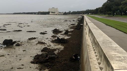
In a rare weather phenomenon, Tampa Bay, along the gulf coast of the state’s western shore, experienced what is referred to as a reverse storm surge. In this rare event, the strong winds from the storm pulled water away from the coast instead of usually pushing it on shore. Milton came in from the south, and its counterclockwise winds blew in from the east, causing the outward flow of the bay. Similar reverse surges happened during Hurricane Ian in 2022 and Hurricane Irma in 2017.
“So this is Tampa Bay,” NewsNation reporter Brian Entin said on a video posted to his X account, where you can see a barren sea floor. “All of the water has run out of the bay. The water is gone. It has been sucked out by Milton.”
State officials urged locals not to venture out to the receding waterline as the waters could come flooding back in at any point and rise in an instant, according to Newsweek.
“STOP: Do not walk out into receding water in Tampa Bay — the water WILL return through storm surge and poses a life-threatening risk,” reads a post on X by the Florida Division of Emergency Management.
The region’s water levels fluctuated through the worst of the storm. Officials from the National Oceanic and Atmospheric Administration say that water levels near Tampa were more than five feet below normal levels at 11 p.m. Wednesday, while the shorelines along neighboring Clearwater and St. Petersburg were down three feet below usual levels at the same time. However, waters there have already started pouring back in.
Tampa avoided an anticipated head-on strike from the storm, and the weather anomaly spared the city from widespread catastrophic damage. However, the city and surrounding areas are expected to continue seeing heavy downpours of rain and incidents of flash flooding through late Thursday afternoon.